


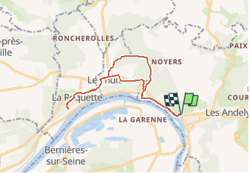
Les Andelys - Le Thuit et ND de Bellegarde

marcel.F
User

Length
13.3 km

Max alt
140 m

Uphill gradient
214 m
Km-Effort
16.2 km

Min alt
7 m

Downhill gradient
211 m
Boucle
Yes
Creation date :
2020-09-14 12:59:35.654
Updated on :
2020-09-16 11:44:02.683
3h40
Difficulty : Difficult

FREE GPS app for hiking
 SityTrail
IGN / Geographical institutes
SityTrail Plus
The world is yours!
About
Trail Walking of 13.3 km to be discovered at Normandy, Eure, Les Andelys. This trail is proposed by marcel.F.
Description
départ hôpital St Jacques aux Andelys
Positioning
Country:
France
Region :
Normandy
Department/Province :
Eure
Municipality :
Les Andelys
Location:
Unknown
Start:(Dec)
Start:(UTM)
383357 ; 5456031 (31U) N.
Comments